How do dry microbursts form?

Daily Wind forecasts, questions about weather, gear, locations, etc.

How do dry microbursts form?

Postby Marty Lowe » Thu Jun 13, 2013 10:44 am

Years ago we lost a good friend to this type of wind.
It was this time of year and this type of forecast.
Keep an eye to the sky, live to kite another day.


Image
Last edited by Marty Lowe on Fri Jun 14, 2013 10:09 am, edited 1 time in total.
User avatar
Marty Lowe
 
Posts: 1307
Joined: Mon Apr 11, 2005 7:09 am
Location: Fruit Heights

Re: How do dry microbursts form?

Postby Marc Hauver » Fri Jun 14, 2013 10:02 am

Great report on micro burst...

The Microburst
By Jim S
Schematic of the Traveling Microburst (Fujita 1981)
Yesterday evening I was working on my computer at home when the Emergency Broadcast System alarm went off on the TV in the adjoining room. It really got my attention since I wasn't expecting much in the way of severe weather, so I thought it was either an Amber alert or perhaps something more serious. I walked over to where I could see the TV and noticed it was a severe thunderstorm warning issued for Salt Lake and Davis County.
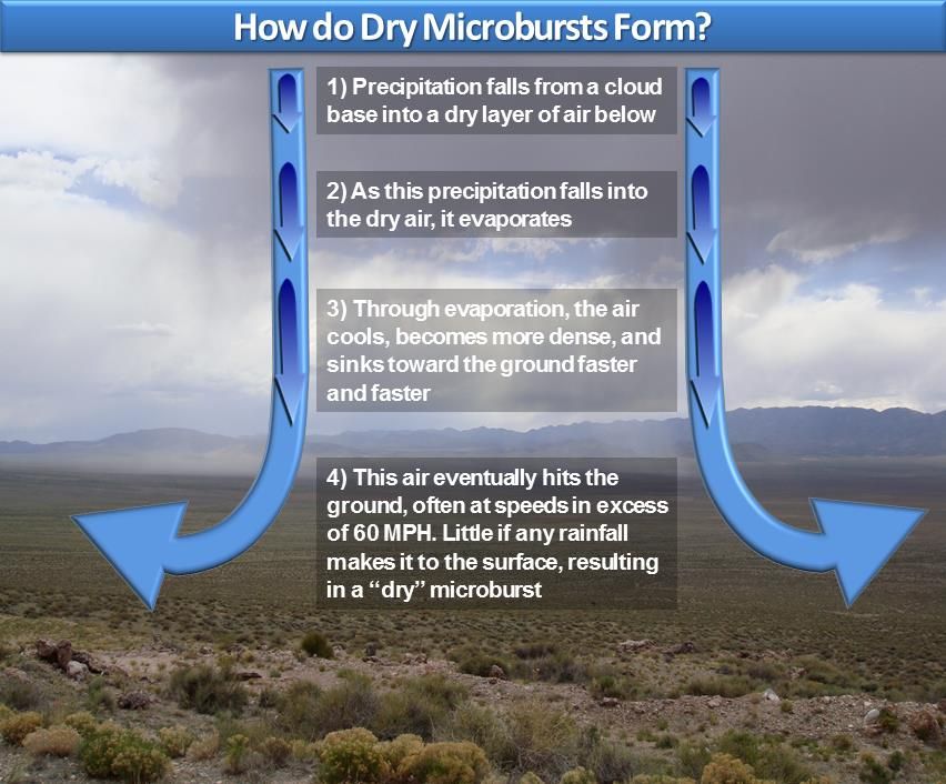
The culprit was a microburst, a localized downburst that produces strong straight line winds at the ground as depicted above. The one we had last night was an example of a dry microburst as most of the precipitation that generated it evaporated before reaching the ground. Some meteorologists differentiate between microbursts and macrobursts depending on the size of the area affected. Indeed, this event may have had macroburst scale, but we will stick with microburst for this discussion.
Dry microbursts are typically generated in Utah by high based storms. Precipitation falling from these storms falls into the dry low-level airmass and evaporates, with the resulting cooling generating an area of locally cool, dense air that sinks very rapidly towards the ground. Environmental conditions were ripe for microburst generation last night with an extremely deep, dry boundary layer extending from the surface to near 500 mb.

Meteorologists use a variable known as Downward Convective Available Potential Energy (DCAPE) to assess the potential strength of downdrafts and downbursts. Last night, the DCAPE was 1684 joules/kg, which is a very high value indicating the potential for downburst-related strong winds. What was needed was some precipitation to get things going.

The curious thing about last nights storm is that it barely showed up on the lowest elevation radar scan that we normally use to examine precipitation (especially in the winter). It was best picked up by the so-called "third tilt", which is at 1.3º relative to the local horizon. Even still, the storm was pretty unimpressive with relatively weak radar reflectivities.

But, the key here was the evaporation of that light precipitation into the dry airmass. And, it led to very strong winds. Here are some storm reports issued by the NWS, which include a 75 mph wind gust. I saw one house on the news with a very large tree on it. The residents of that home were very fortunate that it was well constructed!
Marc Hauver
 
Posts: 82
Joined: Sat Sep 05, 2009 4:23 pm

Re: How do dry microbursts form?

Postby Craig Goudie » Fri Jun 14, 2013 3:10 pm

I have copied this topic and (merged the essential parts) into the Announcments section of the
Forecasts/Where to Ride. It will continue here as well for further comment, but I thought the salient aspects were
important enough to move there as well.

-Craig
Craig Goudie
Sailing the Gorge on my:
8'4" OO Fat Boy, 7'9" OO Slasher, 7'4" Goya SurfWave
with Northwave Sails
User avatar
Craig Goudie
Site Admin
 
Posts: 4329
Joined: Mon Apr 11, 2005 8:53 am
Location: Most Likely--Doug's Beach

Re: How do dry microbursts form?

Postby Jacob Buzianis » Sat May 31, 2014 5:43 pm

I wanted to bring this up to the top on the Main Message Board.

Be Careful out there. It's the beginning of the Microburst season. We lost a good friend 10 yrs ago, 4 people went to the hospital, several almost got killed and a lot of close calls. Keep an eye out for each other and look up in the cloud during your kite session.
Jacob Buzianis
 
Posts: 469
Joined: Sat Apr 23, 2005 1:27 am

Re: How do dry microbursts form?

Postby Todd Jacques » Sat May 31, 2014 5:46 pm

jake I am glad you are posting on here. We should think of safety and retaining our launches. We only have a few left. I do believe if we are not proactive accidents could happen. Marty was a huge advocate for safety and securing launches.
User avatar
Todd Jacques
 
Posts: 286
Joined: Tue Sep 29, 2009 7:04 pm

Re: How do dry microbursts form?

Postby Leo Chan » Sat May 31, 2014 9:24 pm

The clouds were not very friendly north of ULLB today. Mark Johnson told me there was a dry microburt at South Jordan, not far from the gnarly clouds I saw.
Leo Chan
 
Posts: 786
Joined: Fri Aug 22, 2008 6:13 pm
Location: PG

Re: How do dry microbursts form?

Postby RonBert » Wed Jun 11, 2014 12:43 am

Marc Hauver wrote:Great report on micro burst...

The Microburst
By Jim S
...


Just got around to reading this thread. This stuff always sucks me in. Nice write up. With a background in physics, and having worked with some of the FAA weather folks on terminal and en route computer systems development several years back, I developed a weather sweet spot; and a need due to all of my weather dependent outdoor sports. Micro bursts are a native beast in the arid west. When getting here from the damp/humid east coast, I have to hydrate like crazy, and my sinuses are raw if I don’t do the saline spray and humidifier for a week or so to acclimatize. Ventless fireplaces that would soak a room in the east, work great out here.

I think it was the third level radar lobe that lit up the precipitation. I use to do some radar simulation work too, and it got me looking at the weather radar declination sectors rather than just the mosaic. It’s interesting what you can find scanning the individual lobes. Here at the cabin on Strawberry I think I may have even experienced some low density micro burst effects. I’ve seen the rain not more than a mile or two away roll in over me, expecting to get wet, and never feel the rain, just a rush of significant turbulence.

I generally only look at the low beam anymore, other than the mosaic, but this thread makes me inclined to check a few higher lobes when I’m out here; and the barometer. Relative to the cloud ceiling a micro busts effect could be, and likely is, closer than the radar beam angle (line of sight) to the horizon.
RonBert
 
Posts: 33
Joined: Thu May 29, 2014 6:35 pm


Return to Main Message Board

Who is online

Users browsing this forum: No registered users and 26 guests